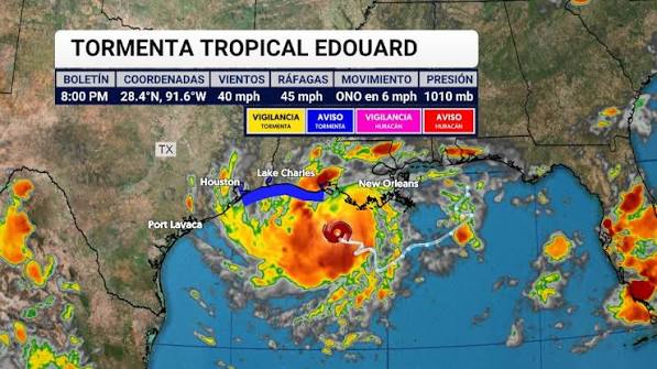
A tropical storm is making a potentially dangerous final approach toward the U.S. Gulf Coast, and forecasters are warning that conditions could deteriorate quickly.
Tropical Storm Edouard is moving toward the Texas-Louisiana coastline Tuesday, September 1, with heavy rain, strong winds, storm surge and flash flooding among the biggest concerns. The National Hurricane Center says Edouard could strengthen significantly before reaching the coast later today.
The storm is not the only major weather story unfolding across the United States and the Pacific. Hurricane Karina has strengthened into a powerful Category 4 hurricane far from land, while the Philadelphia region is also facing an uncomfortable combination of extreme humidity, heat and potentially severe thunderstorms.
For people living along the Gulf Coast, however, Edouard is the immediate concern.
The storm has already pushed rain bands toward the coast, while emergency officials prepare for flooding and potentially damaging winds.
And there is one detail that makes this storm particularly worth watching:
Edouard is approaching warm Gulf waters with time to strengthen before landfall.
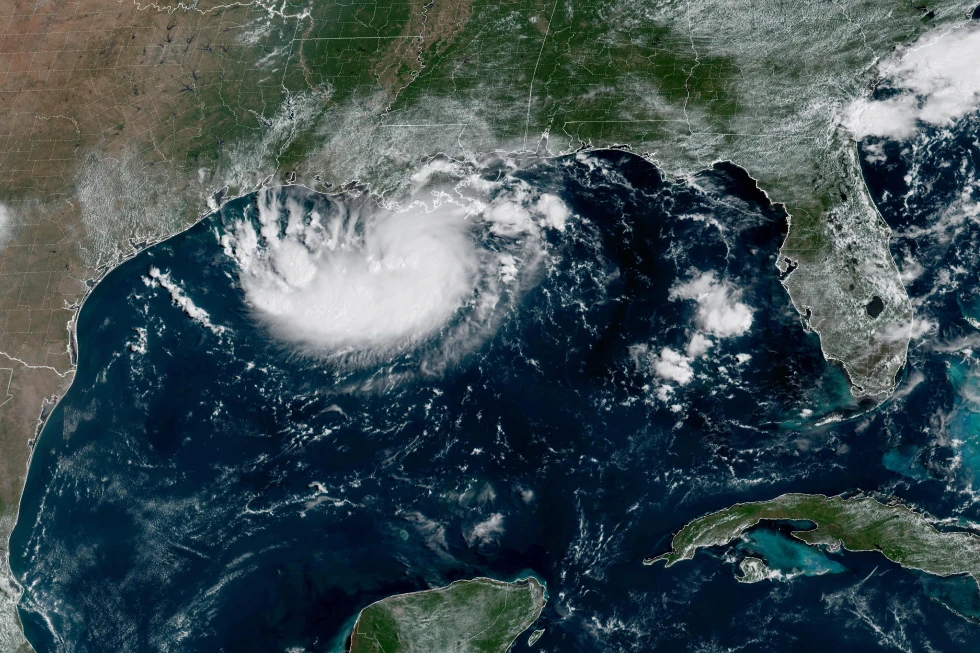
Tropical Storm Edouard Is Closing In on the Gulf Coast
According to the National Hurricane Center’s 4 a.m. CDT advisory Tuesday, Edouard was located about 65 miles south-southeast of Cameron, Louisiana, and roughly 90 miles southeast of Port Arthur, Texas.
The storm was moving west-northwest at about 8 mph, with maximum sustained winds near 40 mph and a minimum central pressure of 1005 millibars.
Those numbers may not initially sound terrifying compared with a major hurricane.
But tropical systems can change rapidly, especially when they remain over warm water.
And forecasters were watching Edouard closely because the storm’s internal structure appeared to be becoming better organized.
The National Hurricane Center said a developing low-level eyewall was becoming visible on radar, while deeper thunderstorms were beginning to reform near the storm’s center.
That could become important for short-term strengthening.
In other words, this isn’t simply a storm that can be judged by its current wind speed.
What happens during the final hours over the Gulf could determine how hard the Texas-Louisiana coast is hit.
Edouard Could Strengthen Before Landfall
The latest forecast information suggests Edouard could become considerably stronger before reaching the coast.
The National Hurricane Center’s forecast at 9 a.m. UTC Tuesday showed maximum sustained winds potentially reaching 55 knots, with gusts up to 65 knots, around the time the storm reaches the coast.
That translates to roughly 63 mph sustained winds and 75 mph gusts.
The forecast called for the center to reach the coast around the Texas-Louisiana border area later Tuesday before moving inland.
Once Edouard moves farther inland, weakening is expected.
But that does not mean the danger immediately disappears.
Tropical storms can produce extremely heavy rainfall long after their strongest winds begin to fade.
And for this system, water may ultimately be a bigger problem than wind.
The Biggest Threat May Be Flooding
Heavy rain is expected across parts of southeastern Texas and southwestern Louisiana.
Forecast rainfall totals have generally been in the range of 3 to 6 inches, with locally higher amounts possible. Some areas along the upper Texas coast could receive as much as 9 inches.
That is enough rainfall to create serious problems, particularly when it falls rapidly.
Urban areas are especially vulnerable because pavement and other hard surfaces prevent water from soaking into the ground.
Low-lying neighborhoods can also flood quickly.
And when tropical rain bands repeatedly move over the same location, rainfall can accumulate much faster than people expect.
The result can be a dangerous situation in which roads become impassable within a short period of time.
That’s why officials have repeatedly warned residents not to drive through flooded roads.
A vehicle can lose traction or become disabled in surprisingly shallow moving water.
Houston Is Watching the Storm Closely
The Houston metropolitan area is one of the places receiving particular attention.
Forecast models indicate that heavy rain could spread across the region Tuesday and into Wednesday morning, with the greatest flooding concern concentrated east of Interstate 45.
Some forecasts have suggested rainfall rates could reach several inches per hour in the heaviest bands.
That is the kind of rainfall that can overwhelm drainage systems quickly.
The storm’s exact track matters enormously.
A shift of even a relatively small distance can change which communities receive the heaviest rain, strongest winds or greatest storm surge.
This is one reason residents should focus less on a single forecast-track line and more on the broader warning area.
A tropical storm does not behave like a narrow highway.
Its rain, wind and surge can extend far away from the center.
Texas and Louisiana Face Multiple Hazards at Once
For coastal communities, Edouard’s danger comes from several factors arriving together.
1. Heavy rain
Rainfall could reach several inches across broad areas, with locally higher totals.
2. Flash flooding
Fast-moving thunderstorms and tropical rain bands could overwhelm drainage systems, particularly in urban and low-lying areas.
3. Strong winds
Wind gusts could become strong enough to bring down tree limbs, damage property and cause scattered power outages.
4. Storm surge
Water pushed toward the coast by the storm can flood coastal communities even before the center crosses inland.
5. Dangerous road conditions
Flooded roads and reduced visibility can make travel extremely hazardous.
The National Hurricane Center has maintained tropical storm and storm surge warnings along portions of the Texas-Louisiana coast.
That means residents in affected areas should not wait until conditions look dangerous outside before taking precautions.
Why Storm Surge Can Be So Dangerous
One of the most misunderstood hurricane hazards is storm surge.
People often focus on wind speed because it is easy to understand.
But storm surge can be devastating even when a tropical cyclone does not become a major hurricane.
Strong winds push seawater toward the coastline.
As the storm approaches land, the water can pile up against beaches, bays, marshes and coastal communities.
That water can then move inland.
The National Hurricane Center had a storm surge warning covering the coastline from High Island, Texas, toward the Vermilion/Cameron Parish line in Louisiana.
For people living near the coast, that is a critical warning.
The danger is not simply whether the storm center passes directly over a particular town.
Water can move well outside the exact path of the center.
Edouard’s Rain Bands Are Already Reaching the Coast
Satellite and radar imagery have been showing increasingly organized convection around Edouard.
Rain bands associated with the storm have already begun affecting parts of the Gulf Coast.
This creates a familiar tropical-storm scenario:
The sky can look relatively normal for a period, followed by a sudden burst of torrential rain and strong wind.
Then conditions can ease again before another band arrives.
That stop-and-start pattern can make tropical storms deceptive.
People may see the rain disappear and assume the danger has passed.
But the center may still be approaching.
For this reason, weather officials generally recommend following official warnings rather than relying on what conditions look like outside a window.
When Is Edouard Expected to Make Landfall?
The latest National Hurricane Center forecast places Edouard near the coast later Tuesday.
The 9 a.m. UTC forecast showed the storm reaching the coast around 18:00 UTC, or approximately early afternoon Central Daylight Time, with stronger winds than it currently has.
The system is then expected to move inland across Texas.
By Wednesday, Edouard should weaken substantially.
The forecast indicates the system could become post-tropical and eventually dissipate shortly afterward.
But again, the weakening phase does not mean all impacts stop immediately.
Heavy rainfall can continue inland.
Rivers and drainage systems may also rise after the storm itself has moved away.
That’s why flooding can sometimes become worse several hours after the strongest winds have passed.
Philadelphia Is Facing a Very Different Weather Threat
While the Gulf Coast prepares for a tropical storm, residents much farther north are dealing with another uncomfortable weather setup.
Philadelphia and surrounding areas are expected to experience hot, humid conditions Tuesday, along with the possibility of severe thunderstorms.
CBS Philadelphia reported that temperatures could climb into the low 90s, while humidity could make it feel closer to the upper 90s or around 100 degrees.
A Heat Advisory was in effect for the urban corridor from noon until 8 p.m.
That creates a potentially dangerous combination.
High temperatures are one thing.
High temperatures combined with extreme humidity can be considerably more stressful for the human body because sweat evaporates less efficiently.
That makes it harder for the body to cool itself.
The “Ring of Fire” Pattern Could Bring More Storms
The weather setup around Philadelphia is also being watched because of a broader pattern sometimes described as a “Ring of Fire.”
The phrase refers to a weather pattern in which a persistent area of heat can help fuel thunderstorms around its edges.
Those storms can repeatedly develop along the boundary between extremely hot air and somewhat cooler air.
For people living in the Northeast, that can mean a strange combination:
hot sunshine during part of the day, followed by sudden thunderstorms later.
And thunderstorms do not need to last for hours to become dangerous.
A storm can produce:
- Powerful wind gusts
- Frequent lightning
- Torrential rain
- Hail
- Localized flash flooding
- Downed trees
- Power outages
The Philadelphia region’s Tuesday forecast therefore carries a different kind of weather risk from the Gulf Coast.
There is no tropical cyclone directly approaching Philadelphia.
But residents can still experience severe weather.
Hurricane Karina Has Exploded Into a Category 4
Meanwhile, thousands of miles away over the Pacific, another remarkable storm has been strengthening rapidly.
Hurricane Karina has reached Category 4 intensity.
The National Hurricane Center reported that Karina had maximum sustained winds around 140 mph, with a minimum central pressure near 950 millibars.
That is a powerful hurricane.
But there is an important piece of good news.
Karina is far from land.
The storm was located well offshore in the eastern Pacific and moving west-northwest.
No coastal warnings were in effect for the U.S. mainland because the hurricane was expected to remain far from land.
Its strength is nevertheless remarkable.
Karina’s development illustrates how quickly tropical systems can intensify when atmospheric and oceanic conditions become favorable.
Why Karina Is Not the Same Emergency as Edouard
It is easy to see headlines about a Category 4 hurricane and assume it is automatically the most dangerous storm in the news.
But hurricane risk is not determined by wind speed alone.
Location matters.
A Category 4 hurricane thousands of miles from land may pose a much smaller immediate threat to people than a weaker tropical storm moving directly into a densely populated coastal region.
That is exactly why Edouard deserves so much attention.
Edouard is considerably weaker than Karina.
But Edouard is moving toward the United States.
Karina is moving away from land.
The distinction is critical.
The Gulf Coast Situation Could Change Quickly
One of the biggest challenges with tropical storms is uncertainty.
Forecast models are improving rapidly, but small changes in the storm’s position or intensity can alter the impacts.
For example, a slightly stronger storm could produce higher winds.
A slightly different track could move the heaviest rain into another community.
A slower-moving storm could dump more rainfall over the same area.
And a change in wind direction can influence storm surge.
That’s why emergency managers and meteorologists continue to update forecasts right up until landfall.
Residents should therefore avoid treating yesterday’s forecast as today’s final answer.
The latest official forecast matters most.
What Residents Along the Texas-Louisiana Coast Should Watch
If you are in an affected coastal or inland area, several things deserve particular attention.
Stay aware of official warnings
Check updates from the National Hurricane Center, National Weather Service and local emergency management officials.
Do not drive through floodwater
Even if the road appears passable, moving water can hide damaged pavement or debris.
Secure outdoor objects
Loose furniture, signs, trash cans and other objects can become dangerous in strong winds.
Charge essential devices
Power interruptions are possible during tropical storms.
Keep emergency supplies accessible
Flashlights, batteries, drinking water, medications and basic food can become important if roads are flooded or electricity is interrupted.
Know your evacuation route
If local officials issue an evacuation order, do not wait until the last minute.
The most dangerous time to leave is often after flooding has already begun.
This Is Not Just a Wind Story
Perhaps the biggest lesson from Edouard is that tropical-storm headlines can sometimes make people focus too heavily on wind speed.
A storm with winds below hurricane strength can still produce life-threatening conditions.
Rainfall can flood homes and roads.
Storm surge can push seawater inland.
Lightning can strike far from the storm’s center.
Tornadoes can occasionally develop within tropical rain bands.
And power outages can affect communities long after the storm has passed.
That’s why emergency officials evaluate tropical cyclones based on multiple hazards, rather than simply asking whether a storm has become a hurricane.
The Bigger Picture: A Busy Start to September
The timing is also notable.
September is traditionally a critical part of the Atlantic hurricane season, and the beginning of the month is arriving with multiple tropical systems and significant weather concerns across different parts of the United States.
Edouard is approaching Texas and Louisiana.
Karina is a powerful hurricane in the Pacific.
Another Pacific system, Tropical Storm Lowell, has also been under observation, while Tropical Storm Marie is near Mexico’s southwestern coast.
At the same time, remnants of earlier tropical activity are contributing to rain and thunderstorms elsewhere.
That does not mean every storm will become a major hurricane.
Most tropical disturbances weaken.
Some remain far offshore.
Others dissipate quickly after moving inland.
But the combination of several systems at once demonstrates why early September can be such an active period for weather watchers.
What Happens Next With Edouard?
The immediate timeline is relatively straightforward.
Tuesday is the critical day for the Texas-Louisiana coast.
Edouard is expected to strengthen before reaching the coast.
Heavy rain will spread inland.
Coastal communities face storm surge and strong winds.
Flooding will become a major concern, especially where intense rain falls over urban or low-lying areas.
Then, as Edouard moves inland, the system should gradually weaken.
By Wednesday, the tropical storm threat should diminish substantially.
But flooding impacts can linger.
Road closures, power outages and standing water may remain even after skies begin to improve.
This is why the aftermath can be just as important as the landfall itself.
The Most Important Question Is Not “Will Edouard Become a Hurricane?”
That question will undoubtedly dominate headlines.
Will Edouard strengthen enough to become a hurricane?
Could it reach hurricane intensity before landfall?
Those are important questions for meteorologists.
But for residents, another question matters more:
How much rain, wind and storm surge will affect my area?
A storm does not need a hurricane designation to become dangerous.
And a storm’s category does not tell the entire story.
The strongest winds may occur away from the location receiving the most rain.
The worst flooding may happen far from the storm center.
And the most serious impacts may continue after the system has weakened.
Bottom Line: Edouard Is a Storm to Take Seriously
Tropical Storm Edouard is moving toward the Texas-Louisiana coast at a moment when conditions could allow it to strengthen significantly.
As of the latest National Hurricane Center information available Tuesday morning, Edouard had sustained winds near 40 mph, was moving west-northwest, and was located just offshore from the Texas-Louisiana region. Forecasters expected additional strengthening before landfall.
The biggest concerns are not limited to wind.
Heavy rainfall, flash flooding, storm surge and dangerous coastal conditions are all part of the threat.
Houston and other communities across southeastern Texas are watching rainfall forecasts particularly closely.
Louisiana’s southwestern coast is also vulnerable as the storm approaches.
Meanwhile, Philadelphia faces its own weather challenge Tuesday, with dangerous heat and humidity mixed with the possibility of severe thunderstorms.
And far out over the Pacific, Hurricane Karina has become a Category 4 powerhouse, although it remains far from land.
For anyone living near the Texas-Louisiana coast, the message is simple:
Don’t wait for the storm to look dramatic before taking it seriously.
Tropical weather can change quickly.
Rain can become flooding.
Flooding can turn roads into hazards.
And a storm that looks relatively modest on a map can still create dangerous conditions on the ground.
As September begins, the U.S. is once again being reminded that hurricane season is not just about watching a forecast cone.
It’s about understanding the hazards inside it.
This article is based on publicly available information and the latest National Hurricane Center and news reports available on September 1, 2026. Tropical cyclone forecasts can change rapidly; residents should follow the latest official guidance from local authorities and the National Hurricane Center.