Updated: October 7, 2026 | Hurricane Forecast, Storm Tracker & Gulf Coast Alerts

Tropical Storm Isaias has formed in the Gulf of Mexico and is forecast to rapidly intensify into a hurricane before approaching the U.S. Gulf Coast late Friday or early Saturday. Residents from Louisiana to the Florida Panhandle face an increasing threat of damaging winds, dangerous storm surge, and potentially significant flooding.
According to the National Hurricane Center (NHC), Isaias could become the first hurricane of the 2026 Atlantic hurricane season by Thursday, October 8, potentially reaching Category 2 strength over the central Gulf before approaching land.
The storm’s exact landfall location remains uncertain, but southeastern Louisiana, Mississippi, Alabama, and the Florida Panhandle are among the areas being closely monitored.
Florida has already declared a state of emergency for 25 counties as officials prepare for possible severe weather.
The most important message for Gulf Coast residents is clear: Do not wait for Isaias to become a hurricane before preparing. Conditions could deteriorate rapidly as the storm approaches the coast.
國家氣象局
+2
Where Is Tropical Storm Isaias Right Now?
As of the NHC’s 4 a.m. CDT advisory on Wednesday, October 7, Tropical Storm Isaias was located in the southwestern Gulf of Mexico, approximately 285 miles west of Progreso, Mexico, and 580 miles southwest of the mouth of the Mississippi River.
NHC OFFICIAL STORM UPDATE — OCTOBER 7, 4 AM CDT
Maximum sustained winds
40 mph
Movement
ENE at 8 mph
Minimum pressure
1004 mb
Storm classification
Tropical Storm
Position: 22.0°N, 94.1°W. These are advisory-time measurements, not live observations.
國家氣象局
+1
Isaias developed from Tropical Depression Nine as thunderstorms became more organized around its circulation.
The storm is currently moving east-northeast, but forecasters expect it to turn northeast and then north as atmospheric steering patterns change over the Gulf.
That anticipated turn will be critical in determining which communities face the most dangerous conditions.
Residents should check the
National Hurricane Center’s official advisories
for updated coordinates, watches, warnings, and forecast maps.
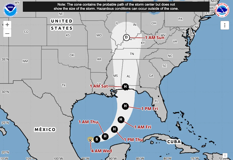
Where Is Tropical Storm Isaias Headed? Latest Forecast Path
The latest forecast indicates that Isaias will move across the Gulf of Mexico before approaching the northern Gulf Coast late Friday, October 9, or early Saturday, October 10.
The potential landfall area extends broadly from Louisiana to the western Florida Panhandle, although current forecasts increasingly focus attention on the central and eastern portions of the northern Gulf Coast.
Expected storm timeline
| Date | Forecast development |
|---|---|
| Wednesday, Oct. 7 | Tropical Storm Isaias strengthens over the southwestern Gulf |
| Thursday, Oct. 8 | Expected to reach hurricane strength and turn toward the northern Gulf |
| Friday, Oct. 9 | Could approach Category 2 intensity while moving toward the coast |
| Late Friday–early Saturday | Potential landfall along the northern Gulf Coast |
| Saturday–Sunday | Heavy rain and gusty winds spread inland across the Southeast |
Timeline based on the NHC’s October 7 morning forecast. Timing and intensity are subject to change.
國家氣象局
Forecasters caution that significant uncertainty remains in both the storm’s direction and speed.
Some computer models favor a more easterly track, while others place the center farther west. Even a relatively small shift could substantially change which communities experience the strongest winds and highest storm surge.
Importantly, the forecast cone represents uncertainty in the storm’s center, not the full extent of its impacts. Dangerous weather can occur well outside the cone.
Could Tropical Storm Isaias Become a Category 2 Hurricane?
Yes. The National Hurricane Center forecasts rapid intensification, with Isaias potentially reaching Category 2 strength before nearing the U.S. coastline.
The NHC’s October 7 morning forecast projected peak sustained winds near 110 mph over the central Gulf, just below the Category 3 threshold.
Hurricane intensity comparison
| Category 1 | 74–95 mph |
| Category 2 | 96–110 mph |
| Category 3 | 111–129 mph |
Several atmospheric conditions could support strengthening:
- Very warm Gulf waters: Sea surface temperatures near the storm are approximately 86–88°F (30–31°C), providing energy for intensification.
- Abundant moisture: A moist atmosphere can help sustain powerful thunderstorms near the storm’s center.
- Relatively limited wind shear: Favorable upper-level conditions may allow Isaias to organize more efficiently during its early development.
However, increasing wind shear closer to the northern Gulf Coast could weaken the storm somewhat before landfall.
That does not eliminate the danger. Isaias could still arrive as a significant hurricane, potentially with an expanding wind field capable of affecting communities far from its center.
國家氣象局
Which Gulf Coast States Are Most at Risk?
Four states face the greatest concern based on the current forecast: Louisiana, Mississippi, Alabama, and Florida.
Although the precise landfall location has not been established, residents throughout the northern Gulf Coast should prepare for changing conditions.
| State | Areas to monitor | Primary concerns |
|---|---|---|
| Louisiana | New Orleans, southeastern coastal parishes | Coastal flooding, heavy rain, gusty winds |
| Mississippi | Gulfport, Biloxi, Pascagoula | Storm surge, damaging winds, flooding |
| Alabama | Mobile, Gulf Shores, Orange Beach | Storm surge, hurricane-force winds, heavy rainfall |
| Florida | Pensacola, Panama City, Florida Panhandle | Coastal inundation, strong winds, flash flooding |
The highest storm surge and strongest onshore winds often occur near and to the right of a hurricane’s track in the Northern Hemisphere.
However, the eventual distribution of impacts will depend on Isaias’s size, intensity, forward speed, and angle of approach.
Texas currently appears less likely to experience the storm’s strongest effects, although rough surf and localized rainfall remain possible along parts of its coastline.
San Antonio Express-News
+1
How Much Rain Could Tropical Storm Isaias Bring?

Heavy rainfall could become one of the most widespread threats associated with Isaias, affecting both coastal communities and inland areas.
Forecasts indicate that much of the central Gulf Coast could receive 3 to 6 inches of rain, with localized totals potentially reaching 10 inches.
Rainfall could begin affecting parts of the Gulf Coast on Friday and spread northward through the weekend.
The primary concerns include flash flooding, overwhelmed urban drainage systems, flooded roads, and rising rivers.
The flood threat will not necessarily end when Isaias moves inland. Tropical systems can transport substantial moisture hundreds of miles from the coastline, causing dangerous rainfall well after their winds weaken.
Portions of the Southeast, including inland Alabama, Georgia, and surrounding states, should monitor local forecasts as the storm progresses.
Never drive through flooded roadways. Water depth and road damage can be difficult to judge, particularly at night.
CBS News
+1
Storm Surge, Power Outages, and Tornadoes: What Residents Should Expect
While hurricane wind speeds receive significant attention, storm surge can be among the deadliest coastal hazards.
Storm surge occurs when strong winds push seawater toward land, causing water levels to rise above normal tides.
Low-lying coastal neighborhoods, barrier islands, waterfront roads, and areas near bays or tidal rivers can be particularly vulnerable.
Isaias could also produce widespread power outages if its strongest winds reach populated coastal communities. Falling trees, damaged power lines, and debris may disrupt electricity and transportation.
Additional hazards could include dangerous surf, rip currents, and isolated tornadoes, especially in rainbands east of the storm’s center.
Residents should understand the difference between a hurricane watch and a hurricane warning. A watch means hurricane conditions are possible, while a warning means they are expected somewhere within the specified area.
For official coastal flood forecasts, consult the
NHC Storm Surge Information
page.
Florida Declares State of Emergency Ahead of Isaias
Florida Governor Ron DeSantis has declared a state of emergency for 25 counties as the state prepares for potential impacts from Tropical Storm Isaias.
The emergency declaration is intended to help state and local agencies coordinate resources and respond more efficiently to severe weather threats.
Officials have highlighted the Florida Panhandle and Big Bend region as areas requiring particular attention.
A state of emergency does not automatically mean every resident must evacuate. Evacuation orders, when necessary, are issued by the appropriate local authorities and depend on the specific hazards facing each community.
Residents should follow county emergency management announcements rather than relying solely on statewide headlines.
The declaration comes as meteorologists warn that Isaias may intensify considerably before reaching the northern Gulf Coast.
NBC Miami
+1
How to Prepare Before Tropical Storm Isaias Arrives

Residents in potentially affected areas should use the remaining preparation time to review their hurricane plans and ensure essential supplies are available.
- Review evacuation routes: Determine whether your home is in a designated evacuation zone and identify where you would go if ordered to leave.
- Prepare emergency supplies: Have drinking water, nonperishable food, medications, flashlights, batteries, and essential personal documents ready.
- Charge electronic devices: Fully charge phones and portable power banks before conditions deteriorate.
- Secure outdoor belongings: Bring lightweight furniture, decorations, and other loose objects indoors.
- Protect important documents: Store identification, insurance information, and medical records in waterproof containers.
- Plan for outages: Prepare for possible interruptions to electricity, communications, and essential services.
Anyone using a portable generator must operate it outdoors, away from windows, doors, and vents, to prevent carbon monoxide poisoning.
People living in mobile homes, flood-prone neighborhoods, or coastal evacuation zones should pay particular attention to local instructions.
The safest decision may depend more on a property’s flood exposure than on the hurricane category alone.
For additional preparation guidance, visit
Ready.gov’s Hurricane Preparedness Guide
.
Why Isaias Could Become the First Atlantic Hurricane of 2026
Isaias is the ninth named storm of the 2026 Atlantic hurricane season, but it could become the season’s first hurricane.
If the storm reaches hurricane strength as forecast, it would mark an unusually late beginning to Atlantic hurricane activity at that intensity.
The Atlantic season officially runs from June 1 through November 30. Hurricane formation is generally most active from August through October, although significant storms can develop later.
El Niño conditions have contributed to an unusually quiet Atlantic hurricane season by favoring atmospheric patterns that can suppress tropical cyclone development.
However, a relatively inactive season does not guarantee safety for coastal communities.
One powerful hurricane can still cause extensive damage, regardless of how many storms formed earlier in the year.
If Isaias becomes the first hurricane on October 8, it would tie the longstanding 1905 record for the latest first hurricane of an Atlantic season.
AP News
+1
Tropical Storm Isaias: Frequently Asked Questions
When will Tropical Storm Isaias make landfall?
The current forecast suggests landfall along the northern Gulf Coast late Friday, October 9, or early Saturday, October 10. The exact location and timing remain uncertain.
Is Tropical Storm Isaias a hurricane yet?
As of the NHC’s October 7 morning advisory, Isaias was a tropical storm with maximum sustained winds of 40 mph. Forecasters expect it to become a hurricane on Thursday.
Will Isaias hit Florida?
Florida’s Panhandle is within the potential impact area, but a direct landfall in Florida is not guaranteed. The storm could also make landfall farther west along the northern Gulf Coast.
Could Isaias reach Category 3 strength?
The October 7 NHC forecast calls for peak winds near 110 mph, the upper end of Category 2. Stronger intensification remains possible, but Category 3 is not the official forecast in that advisory.
Will Isaias affect New Orleans?
New Orleans and southeastern Louisiana should continue monitoring the storm. Even if the center passes farther east, heavy rainfall, coastal flooding, and gusty winds could still pose risks.
Where can I track Tropical Storm Isaias live?
The most reliable source is the
National Hurricane Center
, which provides official advisories, forecast tracks, storm intensity updates, and coastal warnings. Local National Weather Service offices also provide location-specific alerts.
What Happens Next?
The next 24 to 48 hours will be critical for determining how powerful Isaias becomes and where its most dangerous impacts are likely to occur.
Hurricane watches, storm surge watches, and additional local warnings may be issued or updated as forecasters gain confidence in the storm’s path.
Residents across the northern Gulf Coast should closely follow official forecasts, especially those living in flood-prone areas or coastal evacuation zones.
The bottom line: Tropical Storm Isaias is forecast to become a hurricane and potentially approach the U.S. Gulf Coast as a dangerous system this weekend. Its precise path remains uncertain, but the risks of damaging winds, storm surge, and heavy rainfall are already serious enough to justify early preparation.
For the latest official information, monitor the National Hurricane Center and your local emergency management agency.